The proposed development
The Brisbane River today is a great and essential part of the lifestyle that people in Brisbane hold, however, it does create a big barrier that makes it hard to move around freely as there are only few links that allow people to cross. As a result, the proposal of a bridge connecting Riverhills from the end of Sumners Road across to Birkin Road at Bellbowrie was established. It was first planned in the mid-1970s however rejected because it was too early in the city’s development. In 2009 the proposal was brought back forward, suggesting that the bridge from Riverhills to Bellbowrie should be a pedestrian/ cycling link only. There are recent speculations now of whether it should become a road bridge for residents of Moggill and Bellbowrie to avoid traffic congestion on Moggill Road and of course to have a faster route to their destination.
Location Factors
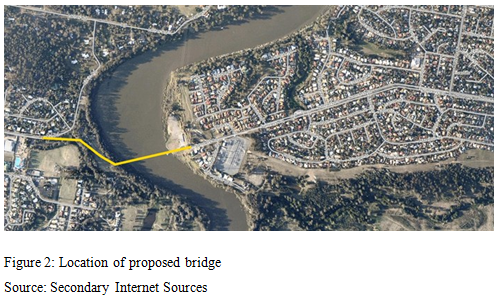
The location of the proposed bridge is between the end of Sumners Road in Riverhills and Birkin Road in Bellbowrie which would stretch about 500m across the river (figure 2). It is approximately at latitude 27.56 S and longitude 152.9 E.
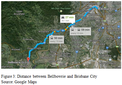
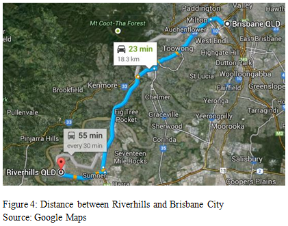
Both Bellbowrie and Riverhills are reasonably the same distance to the centre of Brisbane city with Bellbowrie being 20.1km (figure 3) and Riverhills 18.3km southwest of Brisbane (figure 4). However, residents in Bellbowrie for example must take a long journey of 20.7km which is approximately a 30min drive to reach the Riverhills side (figure 5). This is due to minimal crossings and the nearest road bridge is the Jindalee Bridge, which is 11.6km from Brisbane.
Both Bellbowrie and Riverhills are reasonably the same distance to the centre of Brisbane city with Bellbowrie being 20.1km (figure 3) and Riverhills 18.3km southwest of Brisbane (figure 4). However, residents in Bellbowrie for example must take a long journey of 20.7km which is approximately a 30min drive to reach the Riverhills side (figure 5). This is due to minimal crossings and the nearest road bridge is the Jindalee Bridge, which is 11.6km from Brisbane.
|
|
|

|
Natural Features
On either side of the river the area comprises of community park lands as well as surrounding free government owned unused land. The following will describe the natural features seen on both the Bellbowrie and Riverhills side of the river as well as the natural surroundings of the Brisbane River itself.
Bellbowrie Riverside
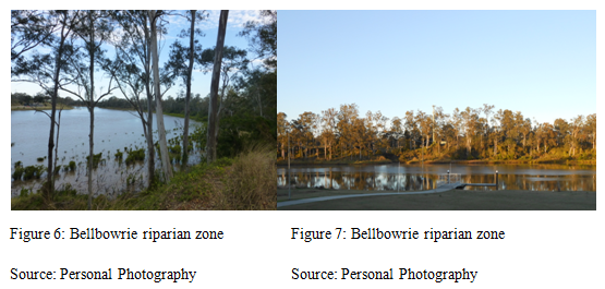
Booker Place Park is located on the riverside in Bellbowrie on Birkin Road. It mostly contains human recreational areas however majority still remains in its natural setting. This is because it owned by the Brisbane City Council so therefore it must remain natural and environmental while also letting humans use the area (figure 6 & 7). Booker Place Park is only accessible from Birkin Road and this park would be compromised if there were to be a bridge development. The bush land around the park’s vicinity consists of approximately 65% canopy cover and its biodiversity is plentiful. There were various species of flora mostly consisting of large trees such as grey iron barks, scribbly gums, and spotted gums. The park itself is reasonably flat however the topography changes as it reaches the river with quite a steep drop to the water. These large trees are also prevalent along the steep river bank and they help provide a dense riparian zone as well as keep the steep bank from sliding. The fauna that can be found are mostly native Australian birds such as; kookaburras, magpies, butcherbirds, rainbow lorikeets, willy wagtails, brush turkeys, and many others. Other small animals include foxes, lizards, and snakes. The soil found in the Bellbowrie area consists of gravelly red and yellow or even deep red loamy top soils over clay.
Riverhills Riverside
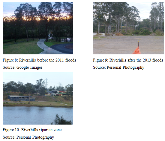
The riverside located at the end of Sumners Road is very different in contrast with the environment in Booker Place Park. The flora of large trees such as eucalyptus, and iron barks is sparse and long grasses are more prevalent (figure 10). It is also evident that many of the trees were planted by people and to improve its bare environment. The topography of this side of the river is also different to the Bellbowrie side because Sumners Road is high and far from the river and then there is a steady slope that goes down to the water. The height of Booker Place Park and Sumner’s Road are about equal and so a level bridge would be able to be accommodated. The soil found in Riverhills is also the same as Bellbowrie. The riparian zone along this section of the river has evidently been affected by floods in the past. Figure 8 shows what the vegetation used to be and figure 9 shows what it is now. In the past, the vegetation was dense and taller trees were prevalent by the water. There was also a lot more animal life because of this. Today, all trees have disappeared, leaving relatively few trees or scrubs for vegetation. There are still some fauna in the area which include kangaroos, and birds such as plovers, magpies, kookaburras, butcherbirds, and cockatoos.
Brisbane River
The Brisbane River has been affected by floods and dredging which has impacted the health of the river. However, ever since river dredging halted in 1993, the health of the river has improved. Pollution minimisation of southeast Queensland waterways also has helped, and although there is still a way to go, the Brisbane River is at its cleanest since the early 1900s. And so the fish are back and the marine life is thriving with many Catfish found in the area. There are also many birds that are always seen around this area of the river which include; pelicans, ducks, and cormorants. Seeing the range of bird species swooping for fish or diving for aquatic plants proves that the biodiversity in and around the Brisbane River is abundant.
Human and Recreational Features
Bellbowrie
|
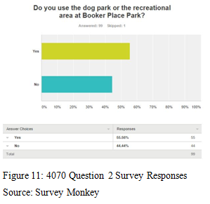
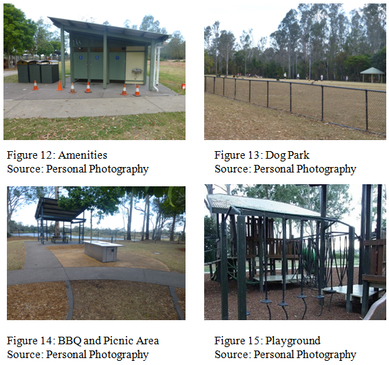
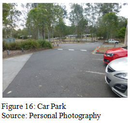
Booker Place Park is publically owned by the Brisbane City Council. The park attracts many locals and even visitors each day due to its free recreational areas and its view towards the Rowing Club and Riverhills suburbs across the Brisbane River. In order to draw people in to use the park and create a place for people to relax and come together, the council have had to build facilities. These include building a very impressive playground (figure 15) for the children that includes wooden forts, slides, swings, flying fox, sand pit, balancing equipment, and climbing nets. There are also wheelchair-accessible toilets (figure 12), bike and walking paths, BBQ’s, picnic tables and shelters (figure 14), rubbish bins, car parks (figure 16), and grassy spaces to use recreationally. Another very popular feature of the park is the large enclosed dog park and in figure 13 it is evident how there are many users of this area. A survey was conducted with the Bellbowrie and Moggill community members and out of 100 people, 55.56% said they use the park and at least 40 of them are using it monthly (figure 11). All these facilities are great for bringing the community together and promoting good health.
|
|
|
The BBQ and picnic areas attract many day visitors however; some are impacting the environment negatively. There are some people who aren’t environmentally conscious and therefore they leave waste pollution behind and create loud levels of noise which disturbs the animals living in the park. Booker Place Park also has no current road through the park that can possibly link to a bridge in the future. This is a problem because it means a lot of the environment would need to be removed and changed to fit in a new road. This extra construction will no doubt make nearby residents angry about this development because of the loss of recreational space.
|
Riverhills
|
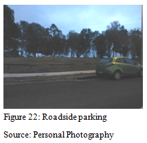
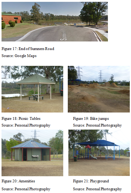
The end of Sumners Road, where the proposed bridge is to be linked to has been left to accommodate the bridge in the future as it is a dead end road (figure 17). However, this would need to be widened and surfaced properly. Since the proposal has been considered in the past, the Brisbane City Council has prepared for an increase in cars by constructing wider road lanes and cycling paths on Sumners Road and in some sections the road is four lanes wide. This enables the already busy road to be capable with the possible increase in cars. The park at the end of Sumners Road helps to attract residents in the area as facilities have been built for them to use. Facilities include picnic tables (figure 18), bike and walking paths, grassy areas and amenities (figure 20), a playground (figure 21) and a popular BMX jumps which attract many children between the ages of 10-18 (figure 19). A problem with this park however is the lack of car parks. This means that visitors are parking along the road, making it sometimes harder for drivers to pass through the narrow road (figure 22). This can be if the proposal of a bridge were to go ahead as people should be able to park somewhere and take their bike and also drive safely. Therefore, car parks should be built as it is necessary for the increase of car and visitors.
|
|
Analysis of current issues - How is the lack of a bridge impacting?
There are a number of current issues that heavily impact the communities in both Bellbowrie and Riverhills due to fact that there are no crossings near the area that are easy to access.
The rise in population of people living in the suburbs is one of the complications as there is now daily congestion along Moggill Road, Sumners Road and the Centenary Motorway. Traffic figures from 2007 show that 12,500 inbound and 15,000 outbound vehicles a day use Moggill road. This is projected to increase to 16,000 and 19,000 by 2026 (O'Loan, 2010). As these roads are main tributaries for people driving to and from the city for work, there needs to be alternative routes for commuters to take which will reduce their traveling time and keep them out of traffic.
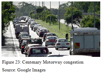
I personally am affected by having no bridge as I live in Bellbowrie and as a rower I travel over to Centenary Rowing Club 5-6 times a week. Having to constantly drive for 30 min to reach the Rowing Club at the end of Sumners Road has meant a lot of money is being spent on fuel and plenty of car emissions are being polluted into the atmosphere. If there were to be a bridge my travelling time would only be 5 minutes which is a great improvement. Driving home after training also means that I get caught in the 7am congestion on the Centenary Motorway (figure 23) and so I can relate with residents of Riverhills when they are concerned about the increase in traffic if more cars were able to access this road from the new bridge.
The rise in population of people living in the suburbs is one of the complications as there is now daily congestion along Moggill Road, Sumners Road and the Centenary Motorway. Traffic figures from 2007 show that 12,500 inbound and 15,000 outbound vehicles a day use Moggill road. This is projected to increase to 16,000 and 19,000 by 2026 (O'Loan, 2010). As these roads are main tributaries for people driving to and from the city for work, there needs to be alternative routes for commuters to take which will reduce their traveling time and keep them out of traffic.
I personally am affected by having no bridge as I live in Bellbowrie and as a rower I travel over to Centenary Rowing Club 5-6 times a week. Having to constantly drive for 30 min to reach the Rowing Club at the end of Sumners Road has meant a lot of money is being spent on fuel and plenty of car emissions are being polluted into the atmosphere. If there were to be a bridge my travelling time would only be 5 minutes which is a great improvement. Driving home after training also means that I get caught in the 7am congestion on the Centenary Motorway (figure 23) and so I can relate with residents of Riverhills when they are concerned about the increase in traffic if more cars were able to access this road from the new bridge.
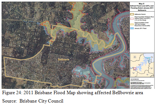
During the 2011 floods in Brisbane, Bellbowrie was severely impacted as people were cut off and left without electricity and minimal food supplies for at least a week. There is obviously a clear need for alternate routes that these residents would’ve needed, to be able to evacuate to safer areas. Because of the current lack of bridge, people are put at risk due to Bellbowrie’s seclusion and the fact that Moggill Road is the only exit route for the whole suburb (figure 24).
Decision Making
Proposal 1: Green Bridge
The construction of a green pedestrian/ cyclist bridge stretching across the Brisbane River from the end of Sumners Road in Riverhills to Birkin Road in Bellbowrie. The green bridge would have to pass through part of Booker Place Park.
Proposal 2: Road Bridge
The construction of a road bridge with two lanes and a pedestrian/ cyclist path. It would stretch across the Brisbane River from the end of Sumners Road in Riverhills to Birkin Road in Bellbowrie. The bridge would cut through part of Booker Place Park in order to connect to Birkin Road for drivers. This proposal would also entail the widening of Sumners Road to allow for two lanes and a cyclist path.
Evaluating the ProposalProposal 1: Green BridgeThe proposal of building a green pedestrian/cyclist bridge can hold many advantages and disadvantages environmentally, socially, and economically. Firstly, the environmental benefits of having a green bridge is that many people from either side of the river will be able to travel to work or other destinations by foot or bike more easily. This is possible because along Sumners Road is a cycling path which then follows along the Centenary Motorway, making it easy to then cycle along the river loop to get to the city for example. People will also be able to cycle across the bridge to access the nearby bus stops. By implementing more possibilities for people from the Bellbowrie and Moggill side (who don’t have access to safe cycling paths) to leave their car at home and improve their health by riding a bike, it will also mean that fuel consumption for these people can be minimised as well as emissions.
There are, however, some people who would be against the proposal as the bridge would have to cut through part of Booker Place Park, and the dog park in particular. The loss of habitat and natural environment will minimise the recreational area that visitors can use and impact the health of the area. If this proposal were to go ahead, the council needs to consider alternative areas to move the dog park in order for Booker Place Park to still be used and attract the locals. Construction of the bridge along the bank of the river can also have environmental impacts. One example is that the removal of trees along the bank where the bridge will go can cause erosion and create unstable ground. The sliding of soils can also impact the health of the river. If a bridge was to be built, the earth needs to be strongly reinforced to prevent the bridge collapsing in the future. A main social benefit of having a link between two suburbs is that it helps to unite communities. It would allow parents in the Bellbowrie/ Moggill area to consider sending their children to other schools nearby such as Middle Park State School, and Centenary State High School. Children would be able to cycle to school whereas Kenmore State High School is too far to travel by bike. There are however some negative social impacts that some residents in both Riverhills and Bellbowrie are concerned about. First of all, the surveys showed that many Bellbowrie residents are concerned that by having a link to a generally lower income suburb (Riverhills) that the crime rate would increase and cause people to feel unsafe. If there were to be an increase in crime this could cause a knock on effect with house prices declining in the area (refer to research). However, crime can happen anywhere and so in contrast, having a green bridge could also potentially increase the prices of houses nearby as people would have easier access to many more services and recreational areas such as; schools, Centenary Rowing Club, community swimming pool, Bellbowrie Shopping Centre, bus services, Booker Place Park, and the park at the end of Sumners Road. A problem with this proposal is the economical costs. Many of the surveyed people from either side of the river felt that constructing a green pedestrian/cyclist bridge would be a waste of time and a waste of taxpayer’s money (refer to research). Since cars cannot cross, only a selection of people in the nearby vicinity and cyclists will use it. There would also be large maintenance costs involved and no return to pay off the bridge. Only few people are benefiting from this bridge if they cycle to work to save money that would be spent on fuel. The most important benefit of building a green bridge instead of a road bridge is that it won’t impact traffic problems on roads such as Moggill Road, Sumners Road, and the Centenary Motorway. Many residents that were surveyed responded that the biggest concern with a development of a road bridge is the increase on cars on their roads (refer to research). However, the development of a green bridge will also not solve the problem of congestion on roads and it also avoids it. Proposal 2: Road BridgeThe second proposal of building a road bridge also has many environmental, social, and economical advantages and disadvantages. To start with, the environmental impact of a road bridge is mostly negative as the bridge needs to be wider to accommodate for cars and pedestrians and there needs to be further construction of roads to link to the bridge. On the Bellbowrie side especially, a large section of the park, especially the dog park will need to be removed in order to fit in this new infrastructure. Many residents and users of the park are against this proposal as they feel this development with ruin the peaceful seclusion of the Bellbowrie area. The loss in habitat and natural environment will minimise the recreational area that visitors can use and impact the health of the area. Another negative is that by having the road and bridge go through a natural area, the native birds and animals will be forced to move away and the biodiversity will decline. Construction of the bridge along the bank of the river can also have environmental impacts. One example is that the removal of trees along the bank where the bridge will go can cause erosion and create unstable ground. The sliding of soils can also impact the health of the river. If a bridge was to be built, the earth needs to be strongly reinforced to prevent the bridge collapsing in the future. The council also needs to consider alternative areas to move the dog park in order for Booker Place Park to still be used and attract the locals.
Environmental benefits of this proposal is that people from either side of the river will be able to minimise the distance they travel and therefore create less emissions and spend less money on fuel. People can also drive, cycle, or walk across the bridge to access nearby bus stops. The Darra train station is located only 6km away from the bridge and so Bellbowrie residents can also commute by train which minimises the use of fuel and reduces the release of emissions. If more people are given easier access to public transport, it will help reduce the number of cars on the road and improve congestion on busy roads. Although, more car parks would have to be built nearby to the bridge and close to public transport to allow people to park their cars and take more environmental forms of travelling around. By creating a link to connect two suburbs on opposite sides of the river, the communities are given many advantages. A great social benefit of having a road bridge is that people will be able to access more services and facilities. For example, residents in Riverhills will be able to use the nearby Bellbowrie shopping centre, community swimming pool, soccer club, Snap Fitness gym, Bellbowrie Tavern, and even the local petrol station. In the survey, many of these residents felt that the bridge would improve their lifestyle due to the fact that they can access more recreational and fitness services (refer to research). It will be great for business in Bellbowrie as there would be an increase in potential consumers which can help businesses become more profitable. This is the same for residents in Bellbowrie who want to access the businesses and industrial services in and around Riverhills and Centenary. Parents can also consider sending their children to other schools because the catchment would change. For high schoolers in Bellbowrie, Centenary State High School would actually be closer to where they live when compared to Kenmore State High School and it provides people with the opportunity to choose between different schools instead of being obligated due to their catchment. This scenario is also similar when comparing Moggill State School and Middle Park State School. Both areas in Bellbowrie and Riverhills have been both affected during the 2011 and 2013 floods. Because of this, a bridge could benefit the communities in the future. In January 2011, Bellbowrie was severely impacted by these floods and it had trapped the residents in the area, cutting them off from the rest of Brisbane. A road bridge that is reasonably high from the water would allow for residents to evacuate the area if any flooding or bushfires were to happen in the future. By providing an out route it would allow residents to be reached by help and they would be able to evacuate and stock up on food. This also means that the bridge would have to be built to be flood proof in order for it to last long term and withstand the pressures of natural disasters. There are negative social impacts that some residents in both Riverhills and Bellbowrie are concerned about with the development of a road bridge. First of all, the surveys showed that many Bellbowrie residents think that by having a link to a generally lower income suburb (Riverhills) that the crime rate would increase and cause people to feel unsafe (refer to research). If there were to be an increase in crime this could cause a knock on effect with house prices declining in the area. However, crime can happen anywhere regardless of a bridge and with an increasing population in Bellbowrie and Moggill from new housing developments it is more likely to have a slight increase in crime anyway. In contrast, having a road bridge could also potentially increase the prices of houses nearby as people would cut travel time and have easier access to many more services and recreational areas such as; schools, Centenary Rowing Club, community swimming pool, Bellbowrie Shopping Centre, bus services, and parks. The increase in cars driving on Sumners Road and using the Centenary Motorway could have a negative impact by creating more congestion on these roads. However, it could improve the congestion as less people in Bellbowrie would use Moggill road which tends to be the main contributor for traffic going into the city, having a following effect on traffic on the Centenary Motorway. The road bridge can also create an increase in unwanted commercial traffic with large trucks using the bridge and commuting traffic it as a shortcut, or so called rat run, giving rise to significant increases in traffic in the area. Some residents who live in Bellbowrie enjoy the current secluded and quiet appeal of the area and they don’t want that to change with a busy road bridge. Perhaps restrictions can be made to prevent the road bridge from becoming a bypass used by unwanted large vehicles. For example, height and weight restrictions can be implemented to make sure large trucks aren’t using the bridge to cut through these suburbs. Economically, this proposal is very expensive and the Brisbane City Council and Queensland State Government would need to find several millions of dollars in funds to even consider the proposal. If it were to go ahead, the tax payers of Brisbane will be affected by this need of funds. Maintenance costs would also be significantly high because the bridge needs to be ensured that it remains flood free, and safe for its users. Long term, the road bridge will be very beneficial to the community. However, there needs to be a way that the bridge can pay itself off over time. Some bridges in the centre of the city were built for millions of dollars and the people that use it pay a toll to cross. This has been beneficial as thousands of people use these bridges each day, meaning that the toll can be cheap and the bridge can be paid off reasonably fast. For this proposal, there needs to be serious consideration of whether a toll should be implemented as less people would use it compared to the busy city and so the toll would have to be slightly higher. Having a toll on the bridge could also mean that people choose to not use the bridge and take their current longer routes. As mentioned earlier, the road bridge would help businesses to cater for more customers and create more profit. The Bellbowrie Shopping Centre for example, would be able to significantly increase the prospects for retail business because it would become busier. This can lead onto businesses being able to expand and become more successful, allowing for the economy of the area to greatly improve and pull in more interest from outsiders. From the possible expansion of much needed retail and other services in both Bellbowrie and Riverhills, more jobs will be available for the locals in the area to benefit from. RecommendationAfter analysing each proposal, both were considered to have merit and be very beneficial to the community. Proposal 1, the green bridge, would provide people with an opportunity for a healthier lifestyle through being able to cycle to work. Reducing the amount of fuel being used thus helping the environment while become healthier is one step closer to becoming more sustainable. However, this proposal seemed to be unpopular with many people of the Bellbowrie and Riverhills community as it only catered for a minority of people. If millions of dollars are to be spent on a bridge, it needs to be able to cater for everyone’s needs. Hence, proposal 2 deemed most beneficial. The road bridge would also allow for healthier lifestyles as well as give residents access to the other side of the Brisbane River to cut travel time and provide alternate and faster routes to destinations. The main problem of proposal 2 however, is that the congestion along said main roads needs to be solved prior to building a bridge to keep residents happy. There are a few possibilities to solving congestion which many of the community members suggested in their survey responses (refer to research) such as:
A third ‘improved’ proposal can be established by combining elements of both proposal 1 and 2. A two lane road bridge with an addition pedestrian and cyclist path on the side provides the communities with a win win situation. By having the best of both worlds and allowing for a path by the side of the road bridge will allow for people to cross safely without being in the way of vehicles. Proposal 3 should also consider adding a bus lane to enable people in Bellbowrie for example to travel from their bus stop straight across the river to be dropped off at Mt Ommaney Shopping Centre or schools. Changed bus routes crossing the bridge can help minimise the amount of people actually driving and reduce the need for more car parks near the bridge. Once the bridge is built there should be a revegetation program which means that the vegetation will be restored to the riverbanks of both the Riverhills and Bellbowrie side. This will help bring back the biodiversity of the area since many animals would have been driven away by the change in environment. One method of keeping the new road bridge economically sustainable is to implement a toll scheme. This could be favourable as the toll would be reasonably cheap and set out over a long period of time. The question is whether people will still use it. They probably would use the bridge as many people would be saving money in fuel and reducing travelling time thanks to the bridge, and therefore they would be willing to pay a small fee to cross the bridge. The implementation of a toll for cars only could also encourage people to become more ‘green’ by travelling on the bus or cycling to avoid any costs. Overall, this final proposal allows for most environmental, social, and economical issues to be solved to see that the bridge stands successful, sustainable, and most of all useful to the community. ConclusionIn summary, the need for a bridge to be built in between Riverhills and Bellbowrie has proved very important. After analysing the current issues associated with the lack of a bridge and the environmental, social, and economic impacts it is clear that solutions for alternative routes need to be made. Hence, the third proposal of a ‘green’ road bridge (which includes tolled car lanes, a pedestrian/ cyclist path, and revegetation of the surrounding area) should be implemented. It shows potential for economic expansion in local businesses, improvement in the environment, and importantly, it will help bring two communities closer and transform their lifestyle.
|
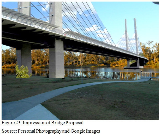
This impression of what the bridge between Riverhills and Bellbowrie would look like is taken as an example from the Eleanor Schonell Bridge.
|
